‘Very alarming’ winter sees Arctic sea ice hit record-low for second year running
Arctic sea ice has reached its peak extent for this winter, clocking in as the joint-smallest in a satellite record going back almost half a century.
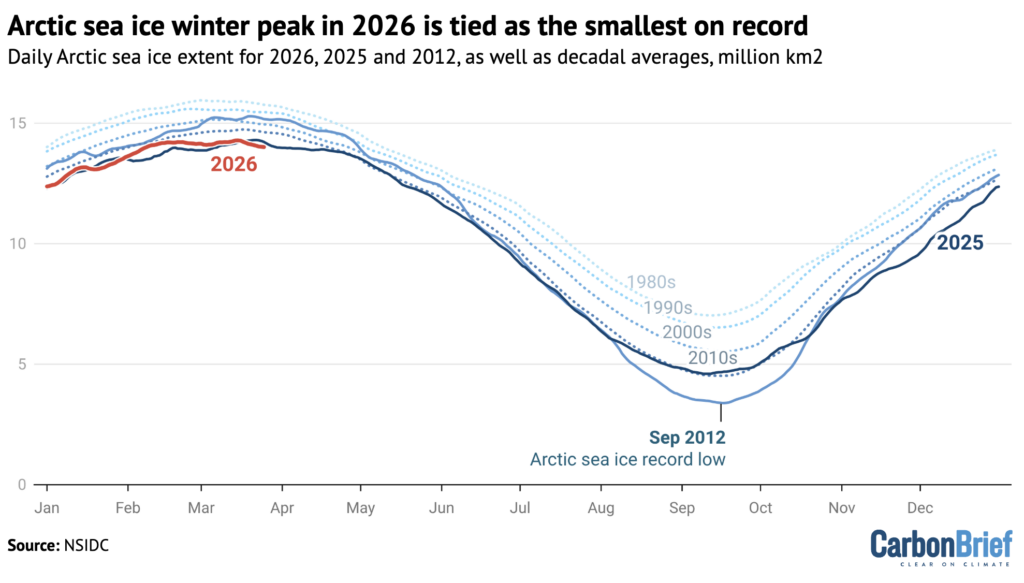
Provisional data from the US National Snow and Ice Data Center (NSIDC) shows that sea ice extent peaked at 14.29m square kilometres (km2) on 15 March.
This is slightly smaller than the previous record for the annual maximum – set just last year – but it counts as a statistical tie, the NSIDC says.
The annual maximum is a key marker in a cycle that sees sea ice extent grow through the cold, dark winter, before melting in spring and summer to a yearly minimum.
The joint record marks a “very alarming” winter for Arctic sea ice, Dr Zack Labe – a scientist at Climate Central – tells Carbon Brief.
And there is more “grim news”, Labe says, as the thickness of the ice is near record lows – meaning that Arctic sea ice is “entering late winter in one of its weakest states in the satellite record”.
§ ‘Unusually warm’
The past six months has seen Arctic sea ice extent “at record or near-record lows, alongside unusually warm conditions” across much of the region, says Dr Lettie Roach, a polar climate scientist at the Alfred Wegener Institute.
These go “hand in hand”, Roach tells Carbon Brief, as “warmer air and ocean temperatures help melt the ice and with less ice, the ocean absorbs more heat, which further speeds up warming”.
The chart below shows Arctic sea ice extent in 2025 (dark blue) and 2026 (red) so far. For comparison, the chart shows decadal averages (dotted lines) as well as 2012 (mid blue), the year of the smallest summer sea-ice minimum on record.
Recent months have seen “strong temperature contrasts” over the northern hemisphere, continues Roach:
“In addition to large parts of the Arctic, temperatures were unusually warm in the western US, southern Europe and eastern Eurasia, while northern Eurasia, northern Canada and the north-eastern US experienced unusually cold conditions.
“That’s linked to a more ‘wavy’ jet stream, which can push cold Arctic air southward while bringing warmer air into the Arctic.”
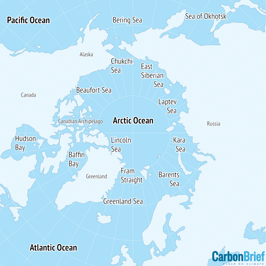
These conditions have contributed to “particularly bad” sea ice levels in regions such as the Sea of Okhotsk, Baffin Bay, Barents Sea and Kara Sea, says Labe. He adds that “one of the only regions with more sea ice relative to normal is across the eastern Bering Sea around Alaska”.
§ ‘Long-term downward trend’
This year’s winter peak is the latest milestone in the “long-term downward trend we’ve observed” in Arctic sea ice since the start of satellite observations in the late 1970s, says Roach.
6According to the NSIDC, the 2026 maximum extent is 1.36m km2 smaller than the 1981-2010 average. That is “equivalent to about twice the size of Texas”, the centre says.
Arctic sea ice is “not just shrinking in extent”, says Roach, it is “also much thinner and more fragile than it used to be”.
Labe notes the “grim news” that sea ice “near the north pole has had record-low thickness for several months now”, adding:
“In February, total Arctic sea ice volume was the second lowest on record. Taken together, Arctic sea ice is entering late winter in one of its weakest states in the satellite record.”
While there is a “lot of year-to-year variability due to natural fluctuations in the atmosphere and ocean”, this long-term decline is “mainly due to human-caused climate change”, says Roach.
Labe adds:
“Human-caused climate change is completely reshaping the polar environment and this is already having wide-ranging consequences.”
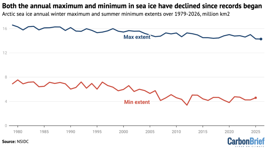
The chart below shows the annual winter maxima (blue) and summer minima (red) since the start of the satellite record.
The chart highlights that the annual maximum has “shown a relatively steady decline over the past 40 years, with the [previous] record low occurring as recently as last year”, says Dr Mika Rantanen, a researcher at the Finnish Meteorological Institute.
This is in “sharp contrast to the annual minimum, where the record [low] still dates back to 2012”, he tells Carbon Brief. This indicates that the summer minimum is “more prone” to yearly ups and downs of natural variability, he explains.
It is for this reason that “it is still too early to say” what the low winter peak means for the forthcoming summer melt season as “regional weather can change quickly”, adds Labe:
“But winter of 2025-26 is another clear signal of just how fast the Arctic is shifting.”
§ ‘Average’ Antarctica
At the Earth’s other pole, sea ice around Antarctica has been melting through the southern-hemisphere summer.
It reached its annual minimum extent of 2.58m km2 on 26 February, the NSIDC says, placing this year as the 16th smallest on record.
For most of the summer, Antarctic sea ice has been “below average”, Dr Clare Eayrs, a postdoctoral researcher at the Korea Polar Research Institute (KOPRI), tells Carbon Brief. However, she continues:
“That changed in January and February, when a shift in surface winds slowed the retreat. Southerly winds over the Weddell Sea pushed existing sea ice northward, keeping coverage higher than expected in that region, while sea ice cover in the Bellingshausen Sea remained low.”
These winds were mostly “redistributing ice rather than new ice forming in these regions”, Eayrs notes:
“This was enough to keep the summer sea ice coverage much closer to average than in the previous four years…It is a reminder that where a season starts does not always determine where it ends.”
Recent years have seen a series of record-low extents in the sea ice that surrounds Antarctica.
While it is “likely” that climate change is influencing Antarctic sea ice, scientists “remain uncertain about the extent and precise mechanisms involved”, says Eayrs:
“This uncertainty is itself an important part of the story. Antarctic sea ice has always been highly variable and its variability has masked any emerging long-term signal for much of the satellite era.”
However, recent research points to a recent “structural change” in Antarctica’s sea ice system, Eayrs notes. This is marked by a greater persistence of low sea ice and a “weaker tendency for the system to return to its earlier mean state”.
In other words, says Eayrs, “when sea ice drops to unusual lows, it no longer bounces back as readily as it once did”.